![]()
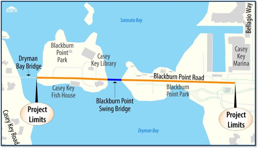
The purpose of the project is to study possible replacement alternatives for the Blackburn Point Bridge on Blackburn Point Road over the Gulf Intracoastal Waterway in Osprey, Sarasota County, Florida. The project consists of two phases. Phase One involves a Project Development & Environment Study (PD&E), which includes environmental and engineering evaluations of alternatives. This phase will be conducted in coordination with the County, incorporating public feedback and establishing design criteria. Phase Two focuses on preparing design documents for the construction of the chosen alternative.
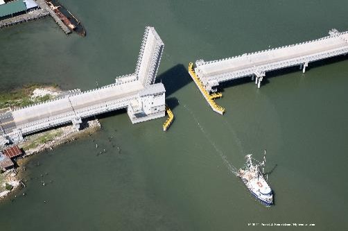
The Blackburn Point Bridge, constructed between 1925 and 1926, is a notable structure located in Sarasota County, Florida. The construction of the Blackburn Point Bridge marked an important development in the infrastructure of Sarasota County during the early 20th century. This bridge has been recognized for its historical significance and is listed on both the National Register of Historic Places and the Sarasota County Register of Historic Places. As a swing bridge, it was designed to allow maritime traffic to pass through while also accommodating vehicular traffic. The bridge’s design and construction reflect the engineering practices of its time, showcasing both aesthetic and functional elements that were prevalent in early 20th-century bridge design. Sarasota County’s Parks, Recreation and Natural Resources as well as the Libraries and Historical Resources Departments will be assisting with honoring the bridge’s historical significance.

https://youtu.be/SqSrP55OOZY
To learn more about the Blackburn Point Bridge Project and other Sarasota County Capital Improvement Projects, click here.
The Blackburn Point Bridge project presents several alternatives for addressing the current infrastructure needs and ensuring safe passage. The options can be categorized into two primary approaches: a No-Build Option and various replacement strategies.
The No-Build Option involves retaining the existing single-lane bridge while performing necessary repairs to maintain its operational status and structural integrity. The No-Build Option is a critical component of the National Environmental Policy Act (NEPA) process. The No-Build Option serves as a benchmark to compare the environmental impacts of proposed actions with a scenario where no action is taken. The No-Build Option is not just a placeholder but a required element that helps in evaluating the effects of a proposed project. By including a No-Build Alternative in the environmental assessment, agencies can better understand the potential environmental consequences of not proceeding with the project, which in turn, aids in making a more informed decision.
Replacing the existing bridge opens up opportunities to improve functionality, safety and mobility. Replacement options will consider a new single-lane or two-lane swing span bridge or a single-leaf bascule span bridge:
A swing span bridge operates by rotating horizontally around a pivot point to allow vessels to pass through. This type of bridge is advantageous in areas where vertical clearance is limited but horizontal space is available for the swing mechanism. It can accommodate larger vessels compared to fixed structures, making it suitable for waterways with significant maritime traffic.

Swing Span
Bascule Span (Single-leaf)
Currently, the bridge offers horizontal and vertical clearances of 51 feet and 9.3 feet, respectively. These measurements fall short of the United States Coast Guard’s (USCG) recommended standards for the Gulf Intracoastal Waterway, which specify a minimum horizontal clearance of 90 feet and a vertical clearance of 21 feet. This discrepancy poses an unreasonable obstruction to navigation, potentially hindering maritime traffic and increasing risks for vessels operating in this area.
A replacement bridge would be constructed on the same alignment as the existing bridge to minimize permanent impacts to adjacent properties.
A temporary bridge is required to maintain traffic while replacing the existing bridge with a new bridge on the existing alignment. A temporary bridge would be constructed north of the existing bridge and would result in temporary impacts to Blackburn Point Park.
Maintaining adequate vertical clearance is crucial for ensuring access to adjacent driveways and properties near the bridge site. Both replacement designs must account for this requirement to avoid disrupting local traffic patterns and accessibility.
Despite its historical value, the Blackburn Point Bridge has several substandard features that have led to its classification as functionally obsolete. One significant issue is its insufficient width, which does not meet modern traffic demands. This limitation poses safety concerns for vehicles navigating across the bridge.
Additionally, the bridge’s railings do not conform to current safety standards, further contributing to its classification as functionally obsolete. These railings are crucial for ensuring pedestrian safety and preventing accidents.
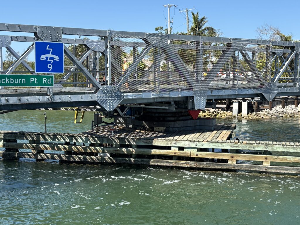
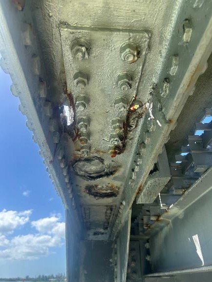
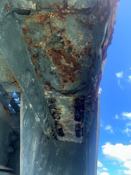
Another critical aspect of the Blackburn Point Bridge is its swing span superstructure and machinery, which are located within what is known as the splash zone. This area is prone to water exposure from waves and weather conditions, potentially leading to accelerated wear and corrosion of structural components. The placement of these mechanical systems in such a vulnerable location raises concerns about their long-term functionality and maintenance needs.
Another issue is the substandard clear roadway width, which accommodates only a single travel lane measuring 16 feet wide. This narrow configuration restricts traffic flow and increases the risk of accidents, especially given the bridge’s frequent use by both vehicles and non-motorized users.
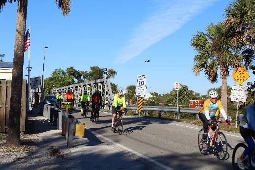
Despite the high volume of daily pedestrian and bicycle traffic, the bridge lacks essential features such as shoulders, sidewalks, or dedicated bicycle lanes. This absence not only endangers pedestrians and cyclists but also contributes to an overall unsafe environment for all users. The lack of these facilities forces non-motorized users to share the limited roadway space with vehicles, heightening the potential for collisions and injuries.
Moreover, the Blackburn Point Bridge fails to meet the minimum lane and shoulder widths prescribed by the American Association of State Highway and Transportation Officials (AASHTO). AASHTO guidelines recommend specific dimensions to ensure safe passage for all types of road users. The failure to adhere to these standards further underscores the inadequacies of the bridge’s design and raises concerns about its ability to safely accommodate current traffic demands.
Another critical aspect of the Blackburn Point Bridge is its swing span superstructure and machinery, which are located within what is known as the splash zone. This area is prone to water exposure from waves and weather conditions, potentially leading to accelerated wear and corrosion of structural components. The placement of these mechanical systems in such a vulnerable location raises concerns about their long-term functionality and maintenance needs.
Another critical aspect of the Blackburn Point Bridge is its swing span superstructure and machinery, which are located within what is known as the splash zone. This area is prone to water exposure from waves and weather conditions, potentially leading to accelerated wear and corrosion of structural components. The placement of these mechanical systems in such a vulnerable location raises concerns about their long-term functionality and maintenance needs.
Another issue is the substandard clear roadway width, which accommodates only a single travel lane measuring 16 feet wide. This narrow configuration restricts traffic flow and increases the risk of accidents, especially given the bridge’s frequent use by both vehicles and non-motorized users.
Despite the high volume of daily pedestrian and bicycle traffic, the bridge lacks essential features such as shoulders, sidewalks, or dedicated bicycle lanes. This absence not only endangers pedestrians and cyclists but also contributes to an overall unsafe environment for all users. The lack of these facilities forces non-motorized users to share the limited roadway space with vehicles, heightening the potential for collisions and injuries.
Moreover, the Blackburn Point Bridge fails to meet the minimum lane and shoulder widths prescribed by the American Association of State Highway and Transportation Officials (AASHTO). AASHTO guidelines recommend specific dimensions to ensure safe passage for all types of road users. The failure to adhere to these standards further underscores the inadequacies of the bridge’s design and raises concerns about its ability to safely accommodate current traffic demands.
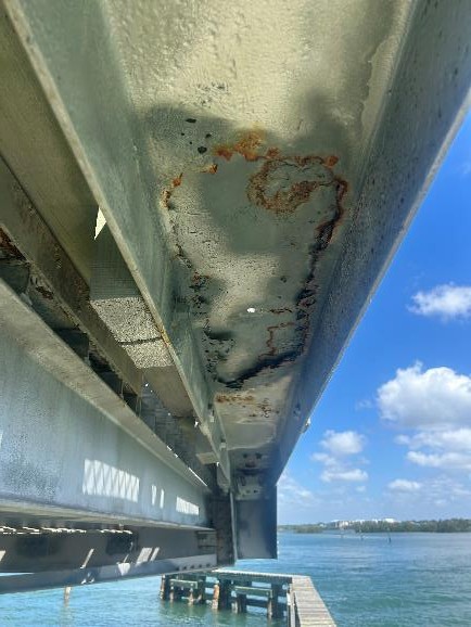
Images below show active corrosion on structural components of the bridge.
The Blackburn Point Bridge serves a critical role in emergency evacuations, particularly during storm events. It is located on Blackburn Point Road, which connects Casey Key to US 41 and is designated as an emergency evacuation route. This designation underscores the importance of the bridge in facilitating safe and efficient evacuations for residents and visitors alike.
However, the existing structure presents significant challenges during emergencies. One of the primary concerns is that there is insufficient room on the bridge to accommodate vehicles passing each other, especially if one vehicle becomes stalled. This limitation can create bottlenecks that hinder evacuation efforts when time is of the essence.
To address these issues, proposed improvements to the Blackburn Point Bridge aim to increase its width. By expanding the bridge, it will allow for adequate space for vehicles to pass around any stalled vehicles, thereby enhancing the overall efficiency of evacuation procedures during emergencies.
In addition to evacuation considerations, there are also important bicycle and pedestrian interactions that need to be addressed. Currently, the bridge lacks sidewalks that comply with accessibility requirements established by the Americans with Disabilities Act (ADA). This absence poses a safety risk for pedestrians who cross the bridge daily. Furthermore, there are no dedicated bicycle lanes on the bridge; instead, it features an open grid metal deck that can be hazardous for cyclists. The existing warning signs instructing cyclists to “Walk Bikes Across Bridge” highlight this concern but do not provide a long-term solution.
The proposed improvements will not only enhance vehicular traffic flow but will also significantly improve safety for pedestrians and cyclists. The plans include adding sidewalks and dedicated bicycle lanes along with replacing the open grid deck with a solid surface. These enhancements will ensure safer passage for all users of the bridge and align with current safety standards.
In addition to navigational concerns, the Blackburn Point Bridge exhibits several vulnerabilities related to marine safety and structural integrity:
Coastal Storm Protection: The existing structure does not meet current standards designed to protect against damage from coastal storm wave action. This lack of resilience raises concerns about the bridge’s ability to withstand severe weather events.
Collision Resistance: The swing bridge design is inadequate for sustaining direct collisions with vessels. Given the high traffic volume on the Gulf Intracoastal Waterway, this presents a significant risk not only to the bridge itself but also to maritime safety.
Corrosion Risks: The low members of the bridge are situated within the splash zone, exposing them to wave impacts during large coastal storms. Additionally, these components are susceptible to accelerated corrosion due to saltwater exposure and salt-laden air, further compromising their structural integrity over time.
Public Meeting was held on June 11, 2026
Public Meeting was held on August 19, 2025.
Public Meeting was held on November 12, 2025.
Public Meeting was held on June 11, 2026
Public Meeting was held on August 19, 2025.
Public Meeting was held on November 12, 2025.
Replacement-in-kind would not address the needs for marine traffic, specifically the existing substandard channel width of 51-feet. The United States Coast Guard has indicated they will not approve a new bridge that does not meet their published horizontal guide clearance of 90-feet.
Rehabilitation would extend the scope of the No-Build Alternative by performing more extensive repairs and introducing modifications to the bridge. Rehabilitation would provide a longer bridge service life than the No-Build Alternative, but due to the bridge’s current age and condition, significant ongoing maintenance repairs and periodic additional major repairs would still be required. It is not practical to extend the bridge service life indefinitely.
As with the No-Build Alternative, rehabilitation would retain the existing bridge geometry that does not meet the needs for safety or mobility. Rehabilitation would also retain the existing navigation clearances. The U. S. Coast Guard’s position is not to approve an action, such as substantial modifications to a bridge, that does not improve the navigation clearances to meet the current guide clearances for the affected waterway.
The cost of the project will be a function of the alternative selected for design and construction. Initial cost estimates for each alternative will be presented at the Alternatives Workshop public meeting.
Following selection of a preferred alternative the project will continue into a design phase to be followed by a construction phase. The timing and duration of these phases will be established based on the alternative and funding availability.
The project is funded for PD&E and Design. The project is not yet funded for construction as funding sources are being evaluated.
Efforts will be made in design and construction planning to keep the existing road open to the extent practical.
The County’s emergency plan is to detour traffic to the Albee Road Bridge to the south. Beyond that, an emergency plan would be developed to address the specific cause of the failure.
Analysis of the existing bridge indicates the structure is adequate to carry the current vehicles. Reducing the weight limit could limit typical garbage trucks, construction trucks, and most importantly EMS vehicles.
No. The project limits do not include the Dryman Bay Bridge or Blackburn Point Road west of the bridge.
Following the Public Hearing, the project will proceed with final design and permitting. The duration for final design, as well as for construction, are dependent upon the selected alternative. In general, final design is expected to take about one year and finish in the 3rd quarter of 2027.
Alternatives Public Meetings were held on August 19, 2025, November 12, 2025, and an additional Alternatives Public Meeting is scheduled for June 11, 2026. The Public Hearing is tentatively scheduled in September 2026 at the Board of County Commissioners.
Traffic will need to be detoured for short durations to safely conduct certain major construction activities. The duration of these detours may vary from 6 to 8 hours overnight to 3 to 5 days. The number of longer detours is not expected to exceed a dozen over the duration of construction. Nighttime restrictions, either short full closures, or lane closures, will be needed for periodic material delivery.
A new bridge will accommodate bikes, cars, and pedestrians concurrently.
Yes, a new bridge with a wider channel will accommodate larger vessels than could use the existing channel. However, few if any larger vessels are anticipated as they have not been recorded passing through other bridges to the north and south that have wider navigation channels. The number of barges is expected to increase as those vessels using the Gulf Intracoastal Waterway would no longer divert around the restricted channel at the Blackburn Point Bridge and out into the gulf.
Yes. The County will provide advanced warning signs to alert the public of any upcoming activities that impact traffic.
The final decision will be made by the County Commission following a recommendation from the project team.
The project is currently not expected to require acquisition of adjacent private property.
Design alternatives will be developed with the goal of avoiding or minimizing impacts to the driveways accessing adjacent properties. Construction of the project will likely require temporary impacts to driveways. As the design alternatives develop these impacts will be assessed and discussed with the property owners, including avoidance and mitigation measures.
The time for a bascule bridge to operate is generally less than for a swing bridge – typically 70 seconds for bascule compared to 100 seconds for swing bridge of the bridge sizes under consideration. This is the time for the movable span to rotate from the closed to open position or visa versa. Note that the total bridge opening time = bridge opening time (70 to 90 seconds) + boat passage time + bridge closing time (70 to 90 seconds), plus time to disengage or engage locking mechanisms and operate traffic gates. The bridge logs indicate about 5-10 minutes per opening for the existing swing bridge. With a wider channel, the time for vessels to clear may be reduced slightly, as some smaller boats can go through in both directions at the same time.
For the most part, impacts to marine traffic will be minimal and consist of partial channel disruptions or limited disruptions in the bridge opening schedule. It is anticipated that there will be times when the channel is fully obstructed (with a barge, for example), done with advance approval of the U.S. Coast Guard and advertised through a Notice to Mariners.
Yes. However, the swing span machinery and foundations are not adequate to support the added weight or pedestrian loading of supplemental sidewalks even using lightweight materials. Sidewalks were added to one of the similar remaining swing spans in Brevard County (the Mathers Bridge), located at the southern tip of Merritt Island. In that case, the entire swing span, machinery and foundations were replaced to accommodate the additional loads of the sidewalk.
The design speed for the road/bridge will not be increased. The County is considering traffic calming measures as part of our design to discourage increased travel speeds.
Yes. The existing bridge is inspected regularly (a minimum of once a year) and rated to carry all Florida legal truck loads in its current state. However, should deterioration continue much further, the bridge rating will likely be lowered in the near future requiring load restrictions until repairs are implemented.
Yes, a single-lane bridge is being considered.
Keeping the existing bridge obligates the County to fund periodic emergency repairs to keep the bridge serviceable and scheduled repairs to address continued deterioration. These costs continue to escalate with time. Current trends and estimates project these costs to exceed $20 million over the next 20 years.
Alternatives Public Meetings were held on August 19, 2025, November 12, 2025 and an additional Alternatives Public Meeting is scheduled for June 11, 2026. The Public Hearing is tentatively scheduled in September 2026 at the Board of County Commissioners.
For questions or more information, please fill out the form below. To receive project updates, please check the box below.
You may also call or email us at the following:
Phone: Timothy Farrell, 941-861-5000 or Email: [email protected]
For questions or more information, please fill out the form below. To receive project updates, please check the box below.
You may also call or email us at the following:
Phone: Timothy Farrell, 941-861-5000 or Email: [email protected]
©2025 Sarasota County.